|
For more information about
Sharm El Sheikh
click here
Sharm El Sheikh Map
Overview of Sharm el Sheikh
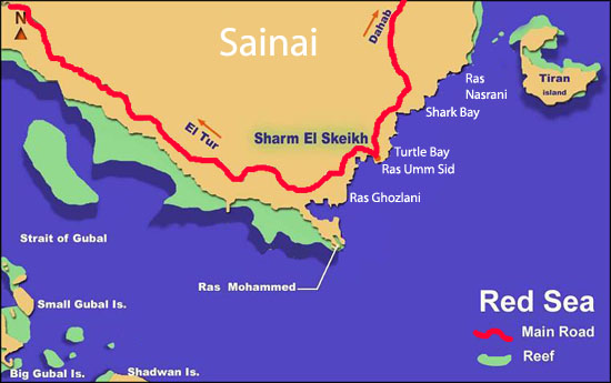
Sharm El Sheikh Map is a
popular tourist destination located on the southern
tip of the Sinai Peninsula in Egypt. Situated on a
promontory overlooking the Straits of Tiran at the
mouth of the Gulf of Aqaba, Sharm el Sheikh holds
strategic importance due to its geographical
location . Originally occupied by the Israelis
from 1967 to 1982, the town was developed into a
thriving resort destination . It is located in
the Janūb Sīnāʾ muḥāfaẓah (governorate) and is part
of the Qesm Sharm Ash Sheikh district in South Sinai
. With its stunning coastal location and a wealth
of attractions, Sharm el Sheikh has become one of
the most popular holiday destinations in Egypt .
Sharm el Sheik map
Map of Sharm El Sheikh
Egypt map Sharm el Sheikh
Map Sharm el Sheikh Egypt
Sharm el Sheikh city map
Sharm el Sheikh on map
Sharm map
Sharm Sheikh map
Sharm El Sheikh Map experiences a desert climate,
characterized by hot, muggy summers and comfortable,
dry winters. The summers are arid and clear, while
the winters are mostly clear and windy . The
average temperature in Sharm el Sheikh ranges from
highs of 91°F (33°C) to lows of 75°F (24°C) in May,
making it a warm and pleasant destination for
travelers . Visitors can enjoy the beautiful
beaches and indulge in various water activities
while basking in the year-round sunshine. For those
interested in exploring the underwater world, Sharm
el Sheikh offers excellent diving and snorkeling
opportunities in the Red Sea.
Sharm el
Sheikh city map
Sharm el Sheikh is home to a plethora of tourist
attractions that cater to a wide range of interests.
One of the top attractions is the Ras Mohammed
National Park, known for its stunning coral reefs
and diverse marine life . SOHO Square, located in
the heart of Sharm el Sheikh, offers a vibrant
nightlife scene with restaurants, cafes, and
entertainment options . The Old Market, also
known as the Sharm el Sheikh Souk, is a bustling
marketplace where visitors can shop for traditional
crafts, spices, and souvenirs . Na'ama Bay is
another popular spot, known for its lively
atmosphere, beach clubs, and water sports activities
. Other attractions include Ras Um Sid, a
snorkeling and diving site, and the historical St.
Catherine's Monastery located in the nearby Sinai
Peninsula . With its diverse range of
attractions, Sharm el Sheikh offers something for
every traveler.
Sharm el Sheikh Map and
Transportation
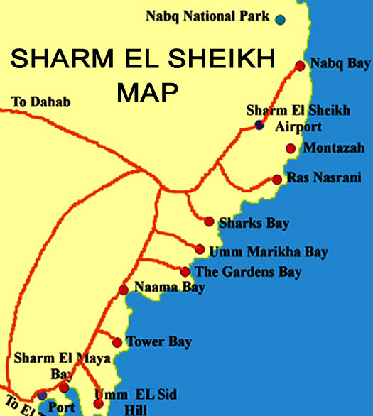
Sharm el Sheikh, a
popular tourist destination in Egypt, boasts a
well-developed road network and highways .
Visitors can easily navigate the town and explore
its attractions using a detailed road map . The
map provides information on routes, traffic updates,
and road network flashes, ensuring a smooth and
convenient travel experience . The town is
divided into several neighborhoods or areas, such as
the Plateau of Um El, each accessible via the road
network . Moreover, ongoing projects aim to fix
and develop existing roads and bridges, as well as
construct new ones, further improving transportation
infrastructure in Sharm el Sheikh .
Sharm El Sheikh Map is served by the Sharm el Sheikh
International Airport, which plays a crucial role in
facilitating travel to and from the town . The
airport is the third-busiest in Egypt and offers
both domestic and international flights .
Passengers can easily navigate the airport using the
Sharm el Sheikh Airport Map, which provides
information on live flight updates, passenger
services, and access to the airport . The
airport is well-connected to various destinations,
allowing visitors to conveniently reach Sharm el
Sheikh .
Map Sharm el
Sheikh Egypt
Sharm El Sheikh Map While public
transportation options in Sharm el Sheikh are
limited, there are still some available choices for
travelers. The local buses, known as "Blue Buses,"
are 15-seat minibusses that operate along the main
roads in Sharm el Sheikh . These buses start
from the old market and cover various routes,
providing an affordable means of transportation for
locals and tourists alike . Additionally, there
are other public transport options, including taxis
and hotel shuttles, which can be utilized to travel
within the town . It is important to note that
public transport from the airport to Sharm el Sheikh
is not available, and taxis or hotel shuttles are
the primary options for transportation .
Exploring Sharm el Sheikh:
Neighborhoods and Landmarks
Sharm El Sheikh Map,
located on the southern tip of the Sinai Peninsula
in Egypt, is a popular tourist destination known for
its stunning beaches and vibrant atmosphere. One of
the most prominent neighborhoods in Sharm el Sheikh
is Naama Bay, often considered the heart of the
city. Naama Bay is a bustling area filled with
hotels, restaurants, and shops, making it the
perfect place for tourists to stay and explore .
Visitors can find a range of accommodations in Naama
Bay, from luxurious resorts to budget-friendly
hotels, all within close proximity to the beach and
various attractions . The bay itself offers a
private beach where visitors can relax and enjoy
activities such as volleyball and snorkeling .
With its lively atmosphere and convenient location,
Naama Bay is a great starting point for exploring
Sharm el Sheikh.
Another neighborhood worth exploring in Sharm el
Sheikh is the Old Market Area. This area provides a
glimpse into traditional Egyptian culture and offers
a unique shopping experience. The narrow streets and
alleyways are lined with eclectic shops selling
spices, textiles, and other traditional Egyptian
goods . Visitors can immerse themselves in
the vibrant atmosphere, haggle with local vendors,
and purchase souvenirs to take home. The Old Market
Area is also home to a variety of restaurants where
visitors can indulge in authentic Egyptian cuisine.
This neighborhood is a must-visit for those seeking
a taste of local culture and a break from the
bustling beachfront .
Sharm el Sheikh
city map
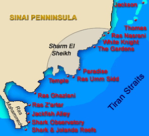
For diving and
snorkeling enthusiasts, Ras Mohammed National Park
is a must-visit destination in Sharm el Sheikh.
Located at the southern tip of the Sinai Peninsula,
this national park is renowned for its diverse
marine life and pristine coral reefs. The
crystal-clear waters offer excellent visibility,
making it a paradise for underwater exploration
. Divers can explore famous sites such as
Yolanda and Shark Reef, known for their vibrant
coral formations and abundant marine species .
Snorkelers can also enjoy the park's underwater
wonders by taking boat trips to explore the reefs
and swim alongside colorful fish . Ras Mohammed
National Park is a natural treasure that showcases
the beauty of the Red Sea and provides unforgettable
experiences for nature lovers and diving enthusiasts
.
Sharm map
  |