|
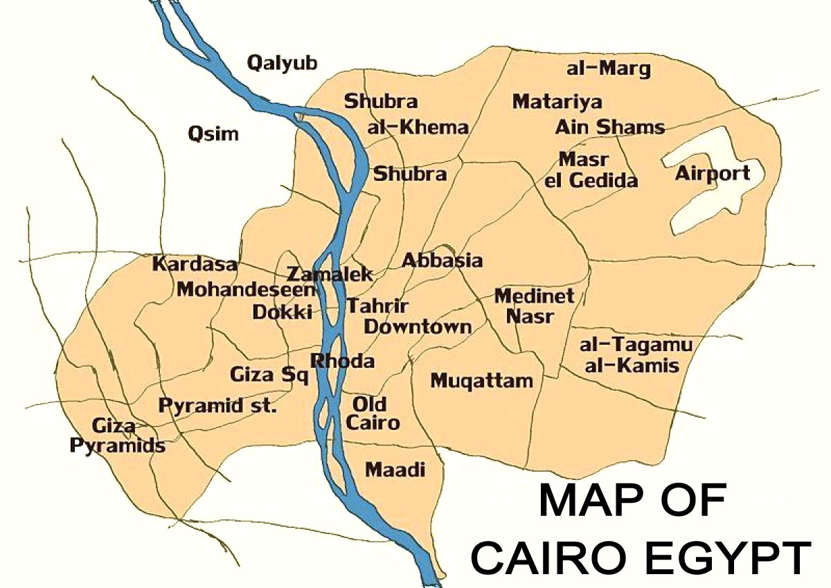
Overview of Cairo and its districts
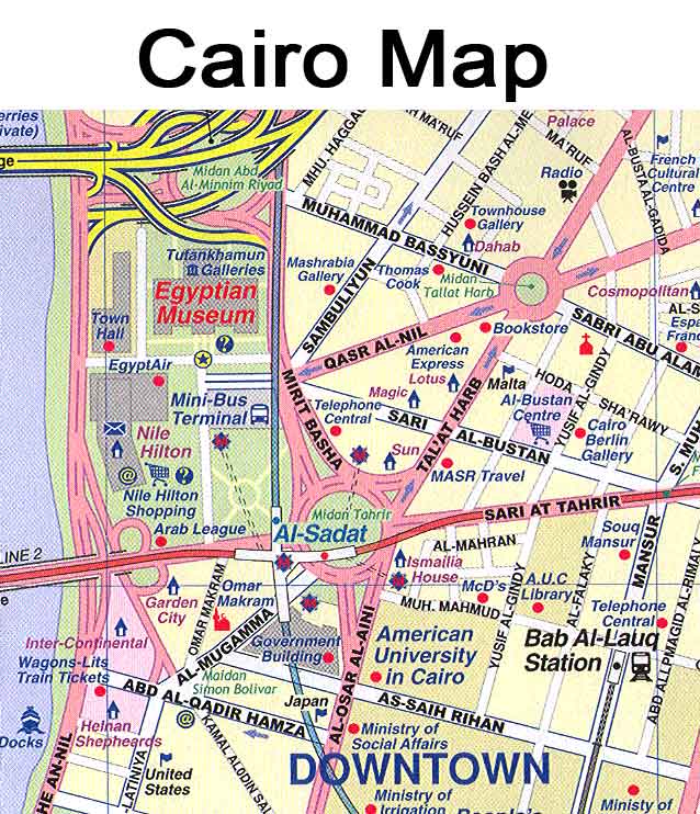
Map of Cairo Egypt
Cairo city map
Cairo map Cairo is the capital of Egypt and
one of the largest cities in Africa, with a
population of over 20 million people . The city
is located on the banks of the Nile River and has a
rich history dating back to ancient times. Cairo is
divided into several districts, each with its own
unique characteristics and attractions. Maps of
Cairo are available to help visitors navigate the
city and explore its many neighborhoods . One
popular map presents Cairo from the right bank of
the Nile, looking towards the southeast with the
Pyramids of Giza and the Great Sphinx appearing at
right .
Some of the most popular districts in Cairo include
Zamalek, Garden City, and Maadi. Zamalek is an
affluent island neighborhood located in the heart of
Cairo, known for its upscale restaurants and cafes.
Garden City is another upscale neighborhood,
featuring tree-lined streets and grand villas.
Maadi, located on the outskirts of Cairo, is a
quieter residential area popular among expats .
Each district in Cairo has its own unique character
and importance, making it a fascinating city to
explore.
Map of Cairo
Map of Cairo Egypt
Cairo city map
Africa map Cairo
Cairo Egypt on the map
Cairo in Africa map
Cairo on a map
El Cairo map
Map of Cairo in Egypt
The importance of each district in Cairo varies
depending on its history, culture, and attractions.
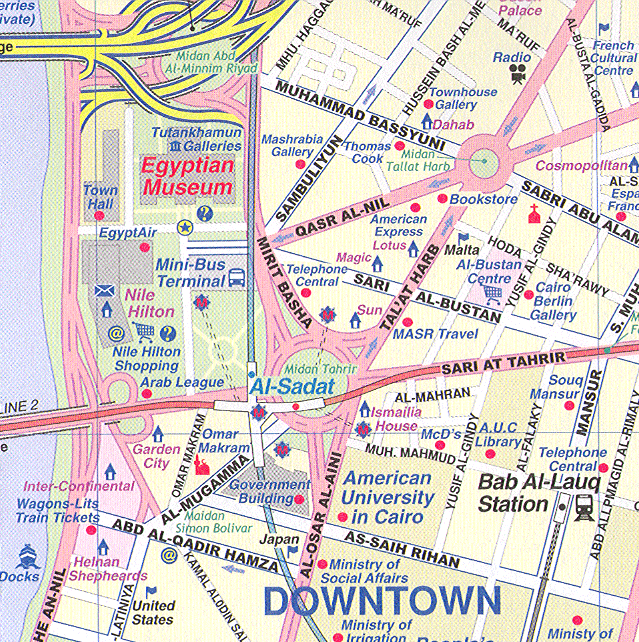
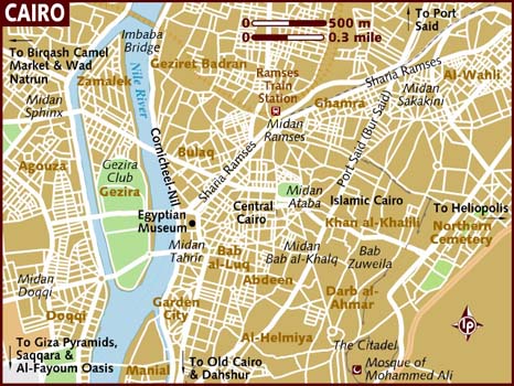
For example, Downtown Cairo is home to many
historical landmarks, including the Egyptian Museum
and the Cairo Tower. Giza, located on the west bank
of the Nile, is home to the famous Pyramids of Giza
and the Great Sphinx. Dokki and Mohandiseen, located
in the Giza suburb, are popular residential areas
with many restaurants and shops . The Cairo
districts map shows all quarters and suburbs of
Cairo, allowing visitors to discover the many areas
and regions of this vibrant city .
Cairo map
Historical landmarks and tourist attractions in
Cairo
Map of Cairo Egypt
Cairo map,
the capital city of Egypt, is home to many famous
landmarks that attract tourists from all over the
world. Some of the most well-known landmarks in
Cairo include the Egyptian Museum, the Mosque of
Muhammad Ali, Al-Azhar Park, the Hanging Church, the
Mosque-Madrasa of Sultan Hassan, the Saladin Citadel
of Cairo, and Al-Azhar Mosque . These landmarks
have significant historical and cultural importance
and offer visitors a glimpse into Egypt's rich
history and heritage.
Each landmark in Cairo has its own unique importance.
For example, the Mosque of Muhammad Ali is a
beautiful mosque that offers stunning views of the
city and is one of the most visited landmarks in
Cairo . The Saladin Citadel of Cairo, on the
other hand, is a medieval fortress that was built to
protect the city from invaders and is now home to
several museums and mosques . The Egyptian
Museum, one of the most famous museums in the world,
houses an extensive collection of ancient Egyptian
artifacts and is a must-visit for anyone interested
in ancient history.
Cairo is also home to many tourist attractions in each
district. Tourists can explore the historic district
of Islamic Cairo, which is home to many mosques,
madrasas, and monuments that date back to the
Islamic era . The district of Giza is home to
the famous Pyramids of Giza and the Sphinx, which
are some of the most iconic landmarks in Egypt .
The district of Zamalek, located on an island in the
Nile River, is known for its upscale restaurants,
boutiques, and art galleries . With so many
landmarks and attractions to explore, Cairo is a
city that offers something for everyone.
Practical information for navigating Cairo
Transportation in Cairo is a crucial
factor to consider when navigating the city. Cairo
has an extensive transportation network that
includes a road system, rail system, subway system,
and maritime services . The Cairo Metro is the
rapid transit system in Cairo, Egypt, and it is
considered one of the easiest and most affordable
ways to get around the city . The metro system
has two lines, and it covers most of the city's
popular tourist destinations. Additionally, mobile
phone technology is being used to GPS track Cairo's
different transit options, and efforts are being
made to create a map of Cairo's public
transportation network . Taxis and
ride-sharing services are also available, but it is
essential to negotiate the fare before getting into
the vehicle to avoid being overcharged.
Cairo map
When it comes to accommodation options in Cairo, there
are various choices available to suit different
budgets and preferences. The most popular areas to
stay in Cairo include Downtown Cairo, Zamalek, and
Giza, which is home to the famous Pyramids of Giza
. There are several luxury hotels,
budget-friendly hostels, and apartments for rent in
these areas. It is important to research and book
accommodation in advance to ensure availability and
secure the best rates.
Cairo map
Safety is a significant concern for tourists
navigating Cairo, but there are several safety tips
that can help ensure a safe and enjoyable trip. It
is recommended to stick to the main tourist areas,
which include Cairo, Alexandria, Hurghada, Luxor,
Aswan, and Abu Simbel, as these areas are considered
safe . However, it is still important to
exercise caution and be aware of your surroundings
at all times. It is also advisable to avoid
traveling alone at night, especially in secluded
areas . Additionally, travelers should take
precautions against diseases by ensuring their
accommodation is insect-proof, using insect
repellent, and wearing long, loose, light-colored
clothing . By being aware and taking necessary
precautions, tourists can navigate Cairo safely and
enjoy all the city has to offer.
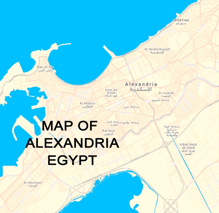
Map
of Alexandria Egypt
Introduction to Alexandria, Egypt
Alexandria, Egypt is a city with a
rich and diverse history. Founded by Alexander the
Great in 331 BC, Alexandria was once considered one
of the greatest cities of the Mediterranean world
and a center of Hellenic scholarship and science
. As the capital of Egypt during the Ptolemaic
dynasty, Alexandria became a major center of
Hellenic civilization, surpassing Memphis in
importance . Today, Alexandria is the second
largest city in Egypt and the largest city on the
Mediterranean coast . Its strategic location has
made it an important industrial center and a pivotal
player in Mediterranean trade . The city is
also home to the Bibliotheca Alexandrina, the New
Library of Alexandria, which is a symbol of
Alexandria's commitment to education and knowledge
.
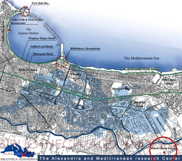
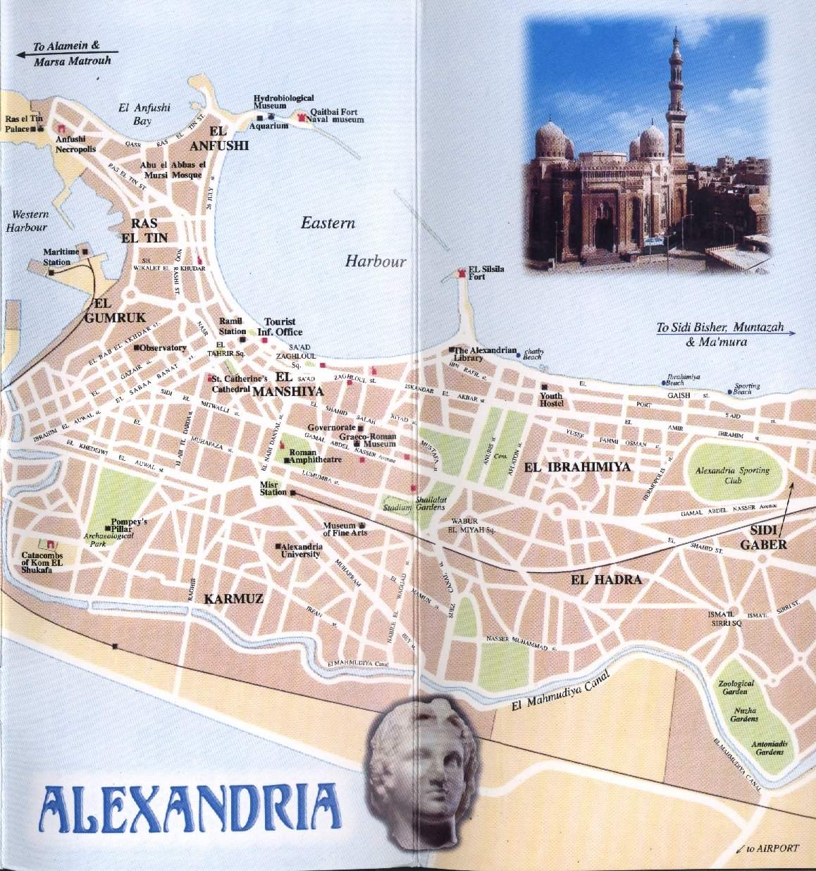
Map of
Alexandria
The map of Alexandria serves as a valuable tool for
understanding the city's layout and history.
Cartography has played a significant role in
documenting the city's development over time, with
the first modern plans of the city produced by
scholars with the expedition to Egypt in the late
18th century . Old maps of Alexandria can be
found online, providing a glimpse into the city's
past . The map of Alexandria also highlights the
city's important landmarks, such as the Bibliotheca
Alexandrina and the ancient lighthouse, which was
one of the Seven Wonders of the Ancient World .
By studying the map of Alexandria, one can gain a
deeper understanding of the city's significance and
how it has evolved over time.
In conclusion, Alexandria, Egypt is a city with a rich
history and cultural significance. Its strategic
location and role in Mediterranean trade have made
it an important industrial center, while its
commitment to education and knowledge is embodied in
the Bibliotheca Alexandrina. The map of Alexandria
serves as a valuable tool for understanding the
city's layout and history, as well as highlighting
its important landmarks. As Alexandria continues to
evolve and grow, its history and significance will
continue to be preserved through cartography and
other means of documentation.
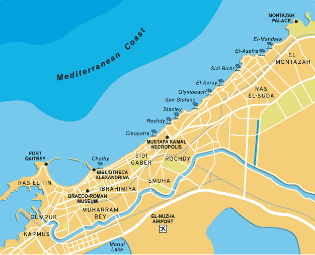
Main attractions and
landmarks in Alexandria
One of the most famous landmarks in
Alexandria, Egypt, is the Great Library of
Alexandria. It was one of the largest and most
significant libraries of the ancient world, and its
collection of books and manuscripts was a symbol of
the city's intellectual and cultural importance .
Today, visitors can explore the Bibliotheca
Alexandrina, a modern library that houses a
collection of over 7,000 maps, including many
focused on Alexandria and the Arab world .
Tourists can also visit the Map Library, which
contains a collection of maps covering all parts of
the world, with a special focus on Alexandria .
The library is a must-visit attraction for history
and book lovers .
Alexandria
Map
Another popular attraction in Alexandria is the
Citadel of Qaitbay, a 15th-century defensive
fortress located on the Mediterranean sea coast. The
citadel was built from 1477 to 1479 AD, during the
reign of Sultan Al-Ashraf Sayf al-Din Qaitbay, to
protect the city from invaders . Today, the
citadel is a major tourist attraction and a symbol
of the city of Alexandria. Visitors can explore the
fortress and its museum, which houses a collection
of artifacts and exhibits related to the history of
Alexandria and Egypt .
Pompey's Pillar is another famous landmark in
Alexandria. It is a Roman triumphal column that was
set up in honor of the Roman emperor Diocletian
between 298–302 AD. The pillar is located on
Alexandria's ancient acropolis and was originally
part of a temple colonnade . Today, it
is a popular tourist attraction and a symbol of the
city's rich history. Visitors can explore the pillar
and the surrounding area, which offers stunning
views of the city and the Mediterranean sea
.
Practical information for
visitors to Alexandria
For visitors to Alexandria, Egypt,
transportation options include the tramway network
and buses . The Alexandria tramway network began
operating in 1863 and consists of 20 lines operating
on 32 kilometers . A transit map for micro-scale
urban development in Alexandria, Egypt has been
created to assist visitors with navigating the city
. This map provides practical information for
visitors, including the location of transportation
options and popular tourist destinations .
Additionally, taxis are readily available for hire
throughout the city.
Accommodation options in Alexandria range from luxury
five-star hotels to budget-friendly options.
Visitors can use interactive hotel finders to search
and compare hotels based on amenities and price
. The Four Seasons Hotel Alexandria at San
Stefano is a popular luxury hotel with a prime
location and stunning views . For
budget-conscious travelers, there are a variety of
affordable hotel options available, such as Plaza
Hotel, Green Plaza Inn Hotel, San Giovanni Hotel,
and Amoun Hotel Alexandria . Visitors should
research and book accommodations in advance to
ensure availability and desired location.
Dining and shopping options in Alexandria are
plentiful, with a variety of restaurants and
shopping malls to choose from. Popular dining
options include Chart House Seafood Restaurant, Chez
Gaby Au Ritrovo, and White & Blue - Greek Nautical
Club . The San Stefano neighborhood is
famous for its architecture, fine dining, and
high-end shopping . Visitors can explore the
city's shopping malls, such as the Alexandria City
Center Mall and the San Stefano Grand Plaza Mall,
which offer a variety of stores and brands to choose
from .
|